|
|
|
|
|
|
| |
Charles Darwin University, Health Department NTT
Funded by AusAID’s Public Sector Linkage Program (PSLP):
Sept 2009 - 30 Sept 2010
A previous PSLP-funded project on pilot applications of health mapping in NTT (July 2008-June 2009) demonstrated efficient rapid field assessment of health facilities in three districts, clinic health data mapping and service availability mapping, and developed a system for efficient recording, reporting and visualisation of clinic health data.
The current project (1 Sept
2009- 30 Sept 2010) aims to expand the infrastructure assessment to also
record services (e.g. emergency obstetric) available at the health facilities,
to extend health mapping capability to more districts, to evaluate the
impacts of implementing a clinic database for recording, reporting, and
visualising health data, and to develop train-the-trainer capacity in
health mapping in NTT.
Background
Basic health levels in Indonesia are a major concern, especially maternal
and neonatal health, particularly amongst the poor, rural communities
of eastern Indonesia. The national health initiative, Healthy Indonesia
2010, promotes the paradigms of disease prevention and health promotion
with health decision-making moved from the national to local (district)
level. This project will build capacity at the district level in setting
up a system for the efficient collection and analysis of health data,
and demonstrate its use for effective health service delivery at the village
level for sites in three districts in NTT.
This project will build on the successful development and use of Geographic Information Systems (GIS) for improved natural resource management in the target districts by adding health data to existing environmental and demographic layers. Indonesian government departments have already demonstrated commitment to sustaining these GIS activities through staff and budget allocations at Provincial and District levels. Training will include in-country activities in the field followed by on-going mentoring, with some work attachments in Darwin.
Project Objectives
The main objective of the project is to enable district government officers
to improve health service delivery at the village level and build capacity
to make decisions regarding allocation of health resources using GIS to
place health and demographic data within a spatial framework.
Engagement in the project will be encouraged by assisting government officers to use this tool to address a high priority health issue, as identified by each district. The applications developed during this project will be demonstrated to a wider audience (from all districts in NTT as well as Provincial government officers and officials) at the end of the project.
The project will provide information and methods for the most effective allocation of health resources, through districts and to villages.
Project
Partners
The project will be implemented in collaboration with the following Indonesian
partner agencies:
– Provincial Health Department (NTT)
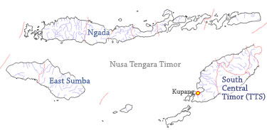
– District Health Departments: Sumba Timur, Timor Tengah Selatan
(TTS) and Ngada, Belu, Kota Kupang, Kabupaten Kupang, Alor, Mangarai Barat
and Flores Timur.
