|
|
|
|
|
|
| |
Assessment
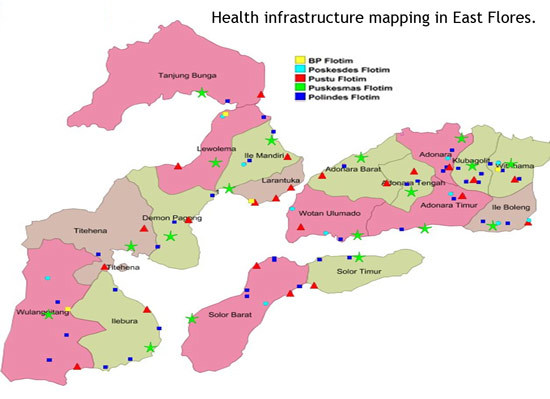
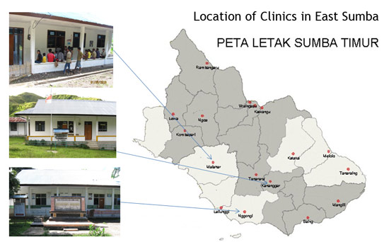
of health infrastructure Recent changes in mobile mapping and GIS technologies have made them appropriate and effective tools for public health applications in rural, developing contexts. Three primary factors are facilitating more wide spread use: (1) decreasing hardware costs, (2) the technological convergence of GPS/mobile-phone/ PDA (personal digital assistant) hardware and (3) the development of free/open-source spatial data software. Through training, tailored to address local issues, capacity was developed amongst health department staff from six dstricts (Kupang, Kupang City, TTS, Flores Timor, East Sumba, Ngada) to collect and interpret data for improved health service delivery. This capacity is particularly important since recent political decentralization in Indonesia has given local government greater control over budgeting and planning. This activity primarily used a GPS enabled HTC mobile phone with free Cybertracker data-recording software for the infrastructure surveys. Training was initially provided during a workshop hosted by the provincial health department in November 2009 with additional follow-up mentoring provided by experienced health department staff from Ngada (Yulius Widiyantoro) and TTS (Nelson) who were participants the previous health mapping project. Presented below are some recent infrastructure survey results: |
 Pak Petrus from Flores Timur collecting health infrastructure data in the field. |